Beacon Fell
6-mile circular walk from Brown Howe
A repeat of a fell I did back in the summer of 2010, I wanted to visit this fell because I remembered how rich it was in flora now better equated with the flora of Lake District I wanted to look into the bogs and tarns of this area.
This walk I did on my own, so starting from the carpark at Brown Howe I crossed the road to a minor road, this took me through a beautiful area of boggy woodland while slowly rising to more open ground.
When I reached this open area of heathland I took a path away from the miner road, it was along this path that I got into more boggy areas, so I stopped went to explore one of these boggy areas.
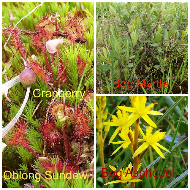
The first plant I noted was the sulphur yellow of Bog asphodel Narthecium ossifragum covering the boggy areas, I took a closer look there were Oblong-leaved sundew, Dorsera intermedia , Bog myrtle Myrica gale, and Cranberry Vaccinium oxycoccos.
 After photographing and some identification, I got back to the footpath and carried on coming across more boggy areas and open water areas, with lots of Bog myrtle around the water edges.
I made it to Beacon Tarn and stopped for my dinner. Sitting there in the sun relaxing it was a joy.After my break it was down to the shoreline following a path around Beacon Tarn, I noticed a plant growing out the water, species identification could not be more difficult, when you can not get near the plant, because of the depth of water it was growing in, so it was down to my camera to get the best results, and then it was not till I got home from my holiday that I could id it, it was Water Lobelia Lobelia dortmanna, an aquatic plant of nutrient-poor lake and tarns.
After photographing and some identification, I got back to the footpath and carried on coming across more boggy areas and open water areas, with lots of Bog myrtle around the water edges.
I made it to Beacon Tarn and stopped for my dinner. Sitting there in the sun relaxing it was a joy.After my break it was down to the shoreline following a path around Beacon Tarn, I noticed a plant growing out the water, species identification could not be more difficult, when you can not get near the plant, because of the depth of water it was growing in, so it was down to my camera to get the best results, and then it was not till I got home from my holiday that I could id it, it was Water Lobelia Lobelia dortmanna, an aquatic plant of nutrient-poor lake and tarns.

I carried on around the tarn and just as I was to start my ascent of Beacon Fell I came across a profusion of Heath-Spotted orchids, and then carried on to the top of Beacon Fell, at the summit I rested and took in the view and then started my descent back to the road. And on to the end of my walk, but back on the minor road I spotted an injured butterfly on the tarmac, it was one species I did not know. It turned out to be a Dark green fritillary.

Wallowbarrow walk 3.5 miles
6-mile circular walk from Brown Howe


Wallowbarrow walk 3.5 miles
Back in the Duddon Valley on the same campsite as before Turner Hall Farm, after setting up camp and having something to eat we set out on an evening walk from the campsite down to Seathwaite church and then taking a footpath into some woodland of birch and oak, the ground flora was cow-wheat another new flower for me.
 |
| Cow-wheat |
We joined the River Duddon and we crossed the bridge and headed for High Wallabarrow Farm.
From the farm it was a steady climb up through woodland passing by many wood ants nest these big heaps of dried leaves and wood, these ants play important roles in woodland ecosystems.
The path starts to level out we come out of the woods with views across the valley, we followed the farm track to the walls of Grassguards, these amazing walls of great height and thickness are beautifully constructed but why did they build them like this? Was it some big field clearance, many of the tops of the walls were covered in moss.
The path starts to level out we come out of the woods with views across the valley, we followed the farm track to the walls of Grassguards, these amazing walls of great height and thickness are beautifully constructed but why did they build them like this? Was it some big field clearance, many of the tops of the walls were covered in moss.

Dow Crag walk
This fell started the Lakeland mission off in the winter of 2009, and I never got a view from the summit on that mission, but I wanted to do this again but this time from the Duddon Valley.
So from the campsite on a morning of sunny spells we set out for Seathwaite Tarn a steady climb up, the tarn itself now a modified to a reservoir, from the tarn we followed a faint path above the tarn, sometimes losing the path only to find it again till we came to Far Gill and then started the climb up to Goats Hause using Far Gill as a rough guide to Goats Hause.
So from the campsite on a morning of sunny spells we set out for Seathwaite Tarn a steady climb up, the tarn itself now a modified to a reservoir, from the tarn we followed a faint path above the tarn, sometimes losing the path only to find it again till we came to Far Gill and then started the climb up to Goats Hause using Far Gill as a rough guide to Goats Hause.
At Goats Hause we stopped and had our dinner, this busy path between Dow Crag and the Old Man of Coniston is where we passed our first fell walkers of the day, as we did not see anybody on the way up.
 |
| Dow Crag |
We started the final climb to the summit of Dow Crag and was rewarded with good views from the summit, now was the descent path down to the Walna Scar path with views of the Duddon Estuary. From the Walna Scar path, we followed it down till we reached tarmac and the path back to the campsite and the end of another good walk.

And that was it another great Lakeland mission, but not the end of my holiday yet, as I wanted to spend the late afternoon at Arnside & Silverdale and visit a special nature reserve.
 |
| Summit view to the Duddon Estuary |

And that was it another great Lakeland mission, but not the end of my holiday yet, as I wanted to spend the late afternoon at Arnside & Silverdale and visit a special nature reserve.
Gait–Barrows National Nature Reserve
We found a parking space near the entrance to Gait-barrows at Challen Hall, and walked into the woodland till we came to the meadow we crossed this and then we picked up a footpath what took us back to the road we followed this till we came to another entrance into the reserve and followed a track to an open area of limestone pavement, and in this area the plant hunter slows down to a crawl looking close in between the clints and grikes of the limestone pavement. It was in this area after identifying several species of plants I came across Lady slippers orchid most of the orchids had died off, but I still found a specimen to photograph this one plant that I came especially to see.
We carried on looking to see what else was to see, I made a list of the plants and photographed them, I also came across a new butterfly species called a Grayling.
 |
| Lady Slipper Orchid |
Last words
And that’s it for another holiday and also the end to the exploration of the south-west, what started off as Wainwright fell bagging as now turned into a full-scale mission of exploration. Many people come to the Lake District National Park just to walk and admire the views nothing wrong with that, but for me to look at any piece of the countryside for the beauty is just one thing of many things I ask myself how did it become like that and so on. My interests in botany, geology and prehistory are my limits, there is much more to this area to discover that I have not mentioned. I have had so many good memories from this part of Cumbria.
The concretions of prehistory sites in this part of Lakeland are many and varied in type from burial cairns and stone circles to settlements. Eskdale moor is just one of many amazing sites that will stick in my memory and also the stone circle of Swinside.
I have now done the highest fells in the Lake District, Scafell Pike four times now from different valleys and every one was joy to do, but the one fell that stood out for me was Bowfell, on one summer evening I sat there on the summit alone for miles about seeing all the other fells about me was such a joy.That mission included a wild camp and that experience of sleeping in such area as the Three Tarns was such a joy to do.
I am glad that I took on Wainwright's Outer Fells because I got to see some great sites like Caw, Beacon Fell and Black Combe and its was on these fells that I learnt to identify the names of the big fells seeing them from distance.
I am glad that I took on Wainwright's Outer Fells because I got to see some great sites like Caw, Beacon Fell and Black Combe and its was on these fells that I learnt to identify the names of the big fells seeing them from distance.
The varied habitats of this area as been fantastic from sand dunes, mountain tops, heathland, and woodland just to name a few, the variation in plant and animal in these habitats. I have fond memories of looking for and listing plants,. Seeing natterjack toads at Sandscale Nature Reserve was a memorable occasion for me. I have only just discovered the mountain flora what will continue to expand. The one plant that stands out for me is the Starry saxifrage, but I also should mention the juniper shrub as being some of oldest species living Cumbria .
The geology is varied in Cumbria and has I am slowly getting to understand it. from Borrowdale volcanic,rocks to some great limestone areas like Birkrigg Common and Arnside and it's this last area I will be revisiting many more times in the coming years, as I start on the central area. I now have a better understanding of this amazing landscape and how it was shaped by the last ice age.
you can read all about my previous adventures on my blog but it is goodbye for now, as I start on a new area the central area as defined by Wainwright. Another voyage of discovery.
you can read all about my previous adventures on my blog but it is goodbye for now, as I start on a new area the central area as defined by Wainwright. Another voyage of discovery.


