Borrowdale
Introduction
This is the second stage now after finishing off the Southwest Lakeland and Alfred Wainwright's book four of the pictorial guides the Southern fells, that being my first book as I am not doing them in order, out of the seven books he as written. Now onto book three of the guides, the central area, and this area will take in more than book three it will also take in the selection of walks taken from Wainwright's Outer Fells book.
The start of the exploration of the central area is going to start in Borrowdale where I completed the last walks of the southern fells, the last time I was here, I missed one fell what was left out from Wainwright's southern fells because of time and that was Seathwaite Fell.
The first base camp was going to be at Rosthwaite village and this mission the first of 2015 and this brings in a new walking companion Sam the dog and a new means of transport a Citroen Berlingo, with the back seats tucked away this now has the benefit of sleeping in.
29/05/15
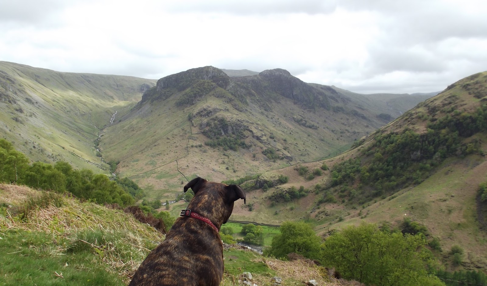
A nice morning of sunshine, with the sound of a cuckoo in the valley, I left the campsite for Stonethwaite valley and followed the minor road to Stonethwaite, through the small village and onto Stanger Gill to start my climb up through the oak woods following the stream up into open ground, with views opening all around me, I carried on following the stream nearly all the way to my first summit of Bessyboot. 550m, (1.804 ft}.
And what a grand view it was from the summit, surrounded by the higher fells, and the view down Borrowdale to Skiddaw.
 |
Bessyboot summit with Skiddaw in background
|
 |
Bessyboot from Rosthwaite Fell
|
Next morning I woke up to rain, so I decided to have a lay in, I had a lazy morning while the weather improved and it did improve so I planned a valley walk to look at the formation of the River Derwent from Rosthwaite to Seathwaite looking at the humps and bumps known as drumlins what are the remains materials left over from the Ice Age again the landscape detective came out of me as I took to reading the landscape. Keeping to the valley floor I used footpaths and a section of the road to Seathwaite over the river and back on footpaths back to base camp.
There were two tributaries to the main Borrowdale glacier: the Stonethwaite and Seathwaite glaciers. Between 18,000 and 10,000 years ago the Stonethwaite glacier retreated in three distinct phases, leaving behind three ridges of the terminal moraine. you can see these near Rosthwaite, at the southern end of the Borrowdale valley. The Seathwaite glacier retreated more quickly, and the melt-water drained around the Stonethwaite snout, creating a glacier-dammed lake. The lake is no longer there, but the former lake bed can be identified.
There were two tributaries to the main Borrowdale glacier: the Stonethwaite and Seathwaite glaciers. Between 18,000 and 10,000 years ago the Stonethwaite glacier retreated in three distinct phases, leaving behind three ridges of the terminal moraine. you can see these near Rosthwaite, at the southern end of the Borrowdale valley. The Seathwaite glacier retreated more quickly, and the melt-water drained around the Stonethwaite snout, creating a glacier-dammed lake. The lake is no longer there, but the former lake bed can be identified.
Eagle Crag and Sergeant's Crag
Back at base camp, I had made myself a meal and now was planning an evening walk to Eagle Crag and Sergeant's Crag so it was as I set off again back into Stonethwaite valley.This walk was another of Wainwright's walks and as I quote from his book
“Eagle Crag is so splendidly situated, so nobly proportioned and of so arresting appearance that it is a far worthier object than the parent fell (High Raise) rising behind”.
 |
Eagle Crag and Sergeant's Crag
|
At the foot of Eagle Crag I could not see any paths, so on deciding on accent of this crag I started to make my up the crag, till got I got to a wire fence and some crags with some careful navigation I got over the fence and the crag and I made my way up to the summit of Eagle Crag with grand views back down the Stonethwaite valley.
Now onto Sergeants Crags with all round views, across the valley was Bessyboot on one side the summits of Glaramara and Allen crag, and not a soul in sight, now to try and find the way down into this side valley bottom, love these small side valleys tucked away from the main valley of Borrowdale.The only way to see these valleys is on foot. Near the valley bottom I found a path and kept the river on my left and headed out of the valley to meet my return path back what I used to get hear before the climb of Eagle Crag another good walk done.
Great Crag
Again the same pattern of weather and another wet morning and so another lazy start to the day has again the weather improved, all packed up and back into Stonethwaite Valley again, this being the last walk in this area, then the plan is to move camp down the valley.
I climbed out of the valley up through the woodland to the top out of the trees and a grand view of Eagle Crag.
I climbed out of the valley up through the woodland to the top out of the trees and a grand view of Eagle Crag.
 |
| Sam |
From summit I could see my next destination Watendlath Tarn and nice steady decent walk, by the time I reached Watendlath the weather had changed to a fine drizzle, I looked about for a place to have my dinner, but could not fine any shelter, so I found a rock to sit on by the stream near the bridge.
 |
| The view down to Watendlath |
 |
| The Summit |
The return route was along the bridleway to Puddingstone Bank, passing through a landscape of heather and bilberry again, and weather had started to improve with the passing of another shower, and again the views improved with views now back into Borrowdale as I made my way back down to Rosthwaite , through the village and I took a footpath to Peat Howe and then back to the campsite.
This corner of Borrowdale was now done it was time to pack up and drive to Grange village and Hollows Farm for the campsite. With that, all done and now on another campsite an another section of Borrowdale this being the middle part of valley.
And what evening and night I had on the campsite with strong winds and heavy rain, I was glad of the van, because next morning there had been several tents destroyed by the storm. And again it was raining this morning but the wind had dropped to a breeze. I sat it out again waiting for a window of opportunity. It did improve I set out again with the intent of climbing Grange Fell, but an hour into the walk the weather turned for the worse and started to rain I pushed on for another 30 minutes but the higher I got the worse it got so I turned back. Back to the campsite after eating I decided on a visit to Keswick to do some food shopping and browse around the shops for the afternoon.
Grange Fell
Today’s weather was good so I packed up a few sandwiches and a flask and walked off the campsite to start my walk, through the village of Grange and over the river to the main road, I followed the river path till I got to Troutbeck and picked up the track what I had used yesterday, and the same footpath through the woods steadily climbing with views through the trees of Derwentwater, to leave the trees behind to walk through heather to the summit of King’s How 392m (1,286ft) and good wide open views of surrounding fells and Derwentwater.

On I went to the summit of Brund Fell with views improving with the surrounding fells coming into view from Brund Fell, from the summit it was downhill to Watendlath.
I reached Watendlath and stopped for lunch at the same place as yesterday but with better weather. I left Watendlath on the same path I used yesterday passing Puddingstone Bank and onto Rosthwaite. I did not take the path into the village but took another path through woodland and down to the main road a short section of road walking and another path took me to visit the Bowder Stone.
I reached Watendlath and stopped for lunch at the same place as yesterday but with better weather. I left Watendlath on the same path I used yesterday passing Puddingstone Bank and onto Rosthwaite. I did not take the path into the village but took another path through woodland and down to the main road a short section of road walking and another path took me to visit the Bowder Stone.
 |
| Bowder Stone |
I left the Bowder Stone to finish my walk off along the road and back into the village of Grange and to the campsite. I moved campsite again to Dale Bottom.
Walla Crag
The next morning I was back in Keswick packed up for a walk and parked up at the Lakeside car park. From the Lakeside car park I wandered over to the theatre and into Hope Park for the view of Derwentwater and the Borrowdale valley with Kings How in the distance and my destination Walla Crag in view, I took a few minutes enjoying the view. I then doubled back on myself back to the car park for a footpath to Cockshot Wood and into Castlehead Wood, in the wood I found another path that took me to a high point with a view out over Derwent Water just lovely.
 |
| Castlehead |
 |
| Four island view |
It’s called Friar’s Crag because it was the departure point for monks sailing to St Herbert’s Island.
I carried on following the shore line path to the modern sculpture set in Calf Close Bay, placed there to commemorate the Centenary of the National Trust in the Lake District. Carved out of a boulder of volcanic rock from the Borrowdale Valley, the unusual design represents ten segments across ten rings, a century. And the end of another interesting walk came as I came full circle back into the car park.
 |
| Calf Close Bay |
Last day of my holiday and day of sunshine and the car was not need today so I and Sam the dog left the campsite and walked the minor road to the foot of High Rigg and there we started to climb the grasses fell to the summit a nice little summit with all the larger fells surrounding it.

We made our way across the fell and came back to the road again for short section passing the little church of St. John’s. I turned off again for a path to Low Rigg where we stopped for a break on the top and sat there soaking up the sun.
In the distance, I could see Castlerigg Stone Circle and see how it sat in the landscape and the fells of Skiddaw and Blencathra and Helvellyn.
Now was the time to make my way there so we set again and after a couple of footpaths and some road walking we had made it to the circle.
This was my third visit to the circle the other two by car and this one on foot and this was the best one because of the weather, the first was ion a cloudy day and the second one was not much better either, but this one was with the sunshine.
This stone circle is one of the oldest in the Lake District; it was built about 4500 years ago in the late Neolithic period. Its size indicates that was important site with its thirty-nine stones some have fallen some still standing, with the main entrance formed by two large stones, and there is a unique rectangular enclosure, built within the ring.
I had a good hour sitting here watching the odd tourist come and go from this magical place.
Then it was time to finish the walk off and it was only a short distance down the hill to the end of the walk.
 |
| Castlerigg Stone Circle |